


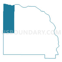
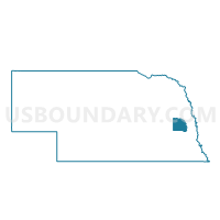
Prague Precinct, Saunders County, Nebraska
About
Outline

Summary
| Unique Area Identifier | 613888 |
| Name | Prague Precinct |
| County | Saunders County |
| State | Nebraska |
| Area (square miles) | 93.45 |
| Land Area (square miles) | 92.96 |
| Water Area (square miles) | 0.49 |
| % of Land Area | 99.48 |
| % of Water Area | 0.52 |
| Latitude of the Internal Point | 41.32971400 |
| Longtitude of the Internal Point | -96.83926990 |
Maps

Graphs
Select a template below for downloading or customizing gragh for Prague Precinct, Saunders County, Nebraska


Neighbors
Neighoring Voting District (by Name) Neighboring Voting District on the Map
- Cedar Bluffs Precinct, Saunders County, NE
- Linwood Precinct, Butler County, NE
- Malmo Precinct, Saunders County, NE
- Oak Creek Precinct, Butler County, NE
- Platte Precinct, Butler County, NE
- Ridgely-Union-Cotterell Precinct- Pleasant Valley, Dodge County, NE
- Skull Creek Precinct, Butler County, NE
- Weston Precinct, Saunders County, NE
Top 10 Neighboring County Subdivision (by Population) Neighboring County Subdivision on the Map
- Chapman township, Saunders County, NE (604)
- Oak Creek township, Butler County, NE (500)
- Chester township, Saunders County, NE (412)
- Cotterell township, Dodge County, NE (403)
- Mariposa township, Saunders County, NE (397)
- Morse Bluff township, Saunders County, NE (381)
- Elk township, Saunders County, NE (289)
- Skull Creek township, Butler County, NE (271)
- Newman township, Saunders County, NE (268)
- Union township, Dodge County, NE (253)
Top 10 Neighboring Place (by Population) Neighboring Place on the Map
Top 10 Neighboring Unified School District (by Population) Neighboring Unified School District on the Map
- Schuyler Community Schools, NE (8,316)
- Wahoo Public Schools, NE (7,198)
- David City Public Schools, NE (5,676)
- North Bend Central Public Schools, NE (2,884)
- East Butler Public Schools, NE (1,902)
- Prague Public Schools, NE (740)
Top 10 Neighboring State Legislative District Upper Chamber (by Population) Neighboring State Legislative District Upper Chamber on the Map
Top 10 Neighboring 111th Congressional District (by Population) Neighboring 111th Congressional District on the Map
Top 10 Neighboring Census Tract (by Population) Neighboring Census Tract on the Map
- Census Tract 9682, Saunders County, NE (5,485)
- Census Tract 9676, Butler County, NE (3,327)
- Census Tract 9637, Dodge County, NE (2,588)
Top 10 Neighboring 5-Digit ZIP Code Tabulation Area (by Population) Neighboring 5-Digit ZIP Code Tabulation Area on the Map
- 68649, NE (1,835)
- 68070, NE (836)
- 68626, NE (614)
- 68050, NE (609)
- 68648, NE (484)
- 68036, NE (402)
- 68040, NE (369)
- 68014, NE (287)